
The Government has announced additional funding to support low-income and rural households that rely on heating oil.
Find out more about the north Norfolk coast
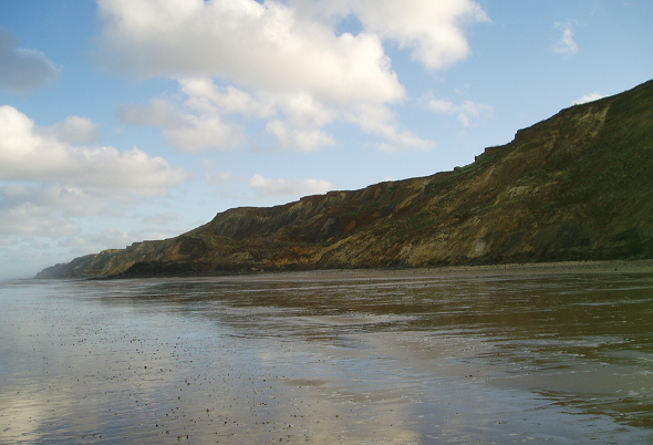
Find out about the north Norfolk coast which runs approximately 68km stretching from Holkham in the west to Horsey in the south-east.
The central 34km of the coastal frontage, from Kelling Hard through to Cart Gap, Happisburgh, is characterised by soft glacial cliffs and sandy beaches.
This is in contrast to the low lying areas found on either flank. In the west, there are saltmarshes and the famous shingle ridge leading to Blakeney Point spit. To the east, the beaches and sand-dunes are all that separates the North Sea from the Norfolk Broads.
Coast Management short films
The following short films have been produced to give an introduction to our coastline and the work going into protection and adaptation in the area.
Introduction to Coastal Management in north Norfolk
Coastal adaptation: a north Norfolk case study
Coastal Management documents
The following documents include introductions to the whole coastal environment in north Norfolk, as well as introductions to the coastal protection and defence of the area.
- Introduction to Coastal Management
- Coastal Adaption
- Coastal Flooding
- Coastal Processes
- Coastal Protection
- Tides, waves and climate change
Case Studies
Coastal erosion
Along the north Norfolk coastline, the cliffs are susceptible to coastal erosion. The prevention of coastal erosion is termed 'coast protection' and is provided by Maritime District Councils such as North Norfolk District Council (NNDC).
The Council is responsible for both constructing and maintaining the defences on its frontage, as set out in the Shoreline Management Plans. The Department for Environment, Food and Rural Affairs (Defra) also provide some funding for coast protection works.
The north Norfolk cliffs
These are basically comprised of a contorted mix of silts, sands, clays and gravels that were deposited during the glacial and interglacial phases of the last 2 million years.
The cliffs provide little resistance to the aggressive action of North Sea waves, which erode the base of the cliffs.
In addition, when the cliff material has a high water content, it becomes unstable and together with wave action, this results in slips and slides of large amounts of material along the coastline, leading to a general retreat of the cliff line.
Coastal flooding
The Environment Agency manages flood defences to reduce the risk of coastal flooding and implements flood warning systems when there is a heightened possibility of flooding.
For further information on flood defences and flooding issues, please visit the Environment Agency flood information page and our own emergency planning flood information page.
Coastal information - intermediate level
Find out what policies have been developed for a particular area of coast, and how they have been executed through specific coast protection schemes.
- Bacton and Walcott Sea Flooding Study 2016 - This report assesses the sea flooding risk at Bacton and Walcott and considers possible mitigation options.
- Happisburgh Rock Sill Recovery and Re-Location 2015 - This report examines the feasibility of recovering the rock and re-using it in a defence structure.
- Mundesley Cliffs Trafalgar Court Beach Access 2014 - Cliff Assessment and Options Appraisal Report
- Cromer to Winterton Ness Coastal Management Non Technical Study 2013 - Is a key action from the Kelling to Lowestoft Shoreline Management Plan (SMP6), which sets out the coastal management policies for that stretch of coast. The technical study improves our understanding of how the coast may change, assists in identifying future coast protection schemes and improves our understanding of the level of resources required to manage our coast for the future.
- Sheringham to Lowestoft SMP Subcells 3b Phase 2 1996 (SUPERCEEDED) - The Shoreline Management Plan Executive Summary 1996.
- Sediment Subcell 3a 2009 - Summary of Adopted Defence Policies
- Sheringham Coast Protection Scheme 2009 - The challenge of protecting the coast at Sheringham.
- Clifton Way Coast Protection Scheme 2009 - The paper describes the work undertaken to stabilise a cliff failure at Clifton Way, Overstrand, which occurred in the early 1990s. The cost of the work undertaken for this scheme was approximately £1.34 million pounds while the total cost of the works, scheme design and associated expenses was about £1.75 million.
- Coast Protection Assets 2009 - The 2001 version of a detailed list of North Norfolk's coast protection assets.
- Ostend to Cart Gap Coastal Strategy Study 2001 - Provides a framework for the sustainable management of the coastal defences between Ostend and Cart Gap, including Happisburgh.
- Cromer Coastal Defence Strategy Study 2003 - Provides a framework for the sustainable management of the coastal defences that extend across the Cromer frontage. The Strategy identifies opportunities and constraints for coastal management over the next 50 years, as well as a more detailed Coastal Defence Implementation Plan for the next 2 years.
Coastal information - advanced level
Large scale studies into coastal defence policies and projects, including sediment transport studies, investigations into management of coastal defences and sustainability of ‘hold the line / do nothing’ policies.
Cromer to Winterton Ness Coastal Management Study 2013
The Cromer to Winterton Study is a key action from the Kelling to Lowestoft Shoreline Management Plan (SMP6), which sets out the coastal management policies for that stretch of coast. This technical study improves our understanding of how the coast may change, assists in identifying future coast protection schemes and improves our understanding of the level of resources required to manage our coast for the future.
Appendices
- Appendix A - Coastal Defence Condition Survey Update
- Appendix B - Economic Assessment Report
- Appendix C - SCAPE Report Modelling of Shore Evolution: Cromer to Cart Gap
- Appendix C - SCAPE Report Addendum
The Bacton, Walcott and Ostend Report 2014
The Bacton, Walcott and Ostend report was completed following the Cromer to Winterton Ness Coastal Management Strategy Study. NNDC appointed Mott MacDonald to undertake a further more detailed investigation into the economic case for coastal protection scheme(s) specifically at Bacton, Walcott and Ostend.
Kelling to Cromer Coastal Defence Strategy Study 2006
The Kelling to Cromer Coastal Defence Strategy Study provides a framework for the sustainable management of the coastal defences of this section of coastal frontage.
Overstrand to Walcott Strategy Study 2002 to 2005
Investigates the sustainability of a selective 'Hold the Line' / 'Do Nothing' management policy, for this section of coastal frontage.
- Strategy Plan - Main Report
- Hydrodynamics
- Littoral Sediment Processes
- Cliff Processes
- Defence Condition Survey
- CliffSCAPE modelling and clifftop recession analysis
- Economic Valuations
- Environmental Value
- "Do Nothing" - Erosion probability and erosion losses
- "Do Nothing" - Flood Probability and Flood Losses
- Consultation (Issues and Concerns)
- Option identification and appraisal
Sediment Transport Report and supporting data.
Appendices
- Appendix 1 - Review of aggregate dredging and disposal activities in the study area.
- Appendix 2 - Summary of sediment processes including definition and plotting of transport rate.
- Appendix 3 - Review of Shoreline Management Plans.
- Appendix 4 - Summary of findings from end user consultations.
- Appendix 5 - End user database.
- Appendix 6 - Report on field data collected in 2001 around Winterton, Clacton and the Humber.
- Appendix 7 - Discussion paper on the influence of storm surges.
- Appendix 8 - Summary of inputs.
- Appendix 9 - Report on mineralogical tracers.
- Appendix 10 - A geological background to sediment sources, pathways and sinks.
- Appendix 11 - Report on Southern North Sea longshore sediment transport.
- Appendix 12 - Computational modelling of sediment transport in the Southern North Sea by tide, wave and surge.
- Appendix 13 - How do the computational modelling scenarios relate to reality?
- Appendix 14 - Summary of sediment sources and sinks.
- Appendix 15 - Map of seabed sediment transport indicators.
Coastal forums
- Norfolk Coastal Forum Part 1 (YouTube)
- Norfolk Coastal Forum Part 2 (YouTube)
Visit the Norfolk and Suffolk Coast Estuary Conference page to find out more.
Coastal planning
At the Council, we can help reduce the risks of coastal change by managing the types of development allowed in coastal risk areas, particularly when considering climate change.
What areas are at risk of coastal change?
The coastal risk areas are known collectively in the government's current National Planning Policy Framework (NPPF) as the Coastal Change Management Area (CCMA). They define this as 'an area identified in plans as likely to be affected by physical change to the shoreline through erosion, coastal landslip, permanent inundation or coastal accretion'.
The CCMA identifies where change will likely be significant over the next 100 years. Use our Policies Map to find out whether land or property is located within the CCMA and if the Local Plan coastal policies will apply when we consider related planning applications.
How are planning decisions affected in these areas?
From a planning perspective, we apply significant weight (a high degree of influence on the final decision to approve or refuse an application) to the coastal planning policies for decision-making within the Local Plan. The coastal planning policies listed below provide details on the types of development that may be acceptable within the CCMA. It also outlines the approach to the potential relocation of homes and businesses:
- Policy CC 5 Coastal Change Management
- Policy CC 6 Coastal Change Adaption
View the relevant planning policies within the Local Plan.
Coastal Adaption Supplementary Planning Document (SPD)
The Coastal Adaption SPD offers guidance on interpreting planning policies for coastal areas. It covers the coast across several local authority areas, from Holkham in Norfolk to Felixstowe in Suffolk.
The objective of the SPD is to make sure that those carrying out development understand the requirements of local planning authorities and that communities can continue to prosper and adapt to coastal change. The document also includes guidance on the expected content of a Coastal Erosion Vulnerability Assessment (CEVA) for when this is needed to support a planning application.
Still need help?
Visit our contact us page for further assistance about our popular services and information.